

Bathymetric & Environmental Surveys
Supporting Climate Resilience & Coastal Innovation in Atlantic Canada

Based in Summerside, Prince Edward Island, Chimera provides advanced bathymetric survey services to support environmental monitoring, climate change adaptation, and sustainable marine development.
Our services are designed to deliver accurate underwater mapping, shoreline analysis, and data-driven insights for organizations, governments, and industries working to safeguard Atlantic Canada’s coastlines and waterways.
Submerged Aquatic Vegetation (SAV) densities and volumes
Delineating zones of sand, mud, and rock
Generating precise contour profiles for shallow water environments.
Meeting survey standards for Fisheries and Oceans Canada (DFO), we produce scientifically defensible population estimates, and with the option for calibrated data to IHO S-44 hydrographic survey standards.

Why Bathymetry Matters for Climate & Coastal Projects
Atlantic Canada faces growing challenges from shoreline erosion, flooding, and rising sea levels. To protect communities and ecosystems, detailed and reliable underwater mapping and depth data is essential.
Research and education – providing accurate datasets for environmental research and climate adaptation initiatives.
Nature-based shoreline adaptation – designing living shorelines, wetlands, and erosion control projects with precision.
Flood & storm surge modeling – creating reliable forecasts and risk assessments.
Blue carbon & habitat studies – monitoring seagrass, eelgrass, and carbon-storing ecosystems.
Tourism and infrastructure resilience – protecting wharves, harbours, and waterfront assets.
Biomass
Volumes
Submerged Aquatic Vegetation (SAV) densities and volumes
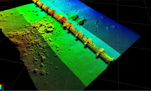
Bathymetry
Depth
Accurate 2D & 3D depth profiles – referenced to WGS84 datum
Substrate Classification
Bottom Typing reports including hardness and substrate depth
Water Column Datalogging
Dissolved Oxygen, Salinity, Temperature, Turbidity, Current
Harbour & Dredging Depth Profiling
Chimera also offers specialized depth profiling for marine infrastructure projects.
- Pre-Dredging Surveys: Establish baseline depth profiles to identify areas requiring excavation.
- Post-Dredging Verification: Confirm project outcomes with precise depth measurements and compliance reports.
- Sediment Movement Analysis: Monitor harbour channels, inlets, and mooring areas over time.
- Harbour Maintenance Planning: Provide data that supports efficient, environmentally responsible dredging schedules.
These services are essential for fisheries, harbour authorities, municipalities, and coastal developers who require accurate, defensible data for regulatory approvals and funding applications.

Inshore & Coastal ROV Services
At Chimera, we can also offer inshore coastal ROV (Remotely Operated Vehicle) services to support marine research, inspection, and environmental monitoring across Atlantic Canada. These services complement our bathymetric mapping by providing detailed underwater visuals and condition assessments in areas where sonar alone cannot capture the full picture.
Services & Deliverables:
Detailed Reports & Media Packages – condition assessments and digital deliverables for research or regulatory compliance.
Underwater Video & Photography – high-resolution visual inspections of seabeds, structures, and habitats.
Habitat & Marine Life Surveys – documenting eelgrass, shellfish beds, and aquatic ecosystems.
Infrastructure Inspection – assessing wharves, pilings, hulls, and moorings for damage, wear, corrosion and scouring.
Seabed & Object Identification – locating debris, lost gear (ghost nets), and submerged obstacles.
ROV System Training & Sales – hands-on instruction and equipment supply for organizations adopting their own underwater capability.


MarineNav Oceanus Pro ROV

Why Work With Chimera?
Local Advantage: Based in PEI, we can mobilize quickly across Atlantic Canada, reducing costs and turnaround time.
Climate Project Alignment: Our services strengthen applications to programs (like the PEI Climate Challenge Fund) by providing measurable, science-based data.
Cost-Effective Solutions: Competitive pricing and scalable services suitable for community projects and large-scale research alike.
Trusted Expertise: Backed by experience in environmental bathymetry, surveying, and geospatial data interpretation.
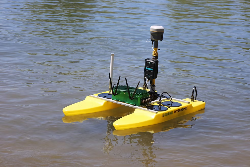
Sonar-Equipped USVs (Unmanned Surface Vessels) and survey boats delivering high-resolution bathymetric mapping.
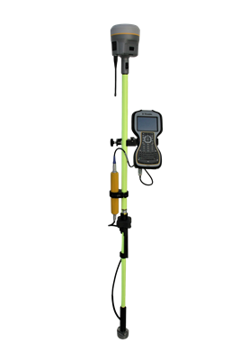
RTK GNSS Integration for survey grade ‘sub-centimetre’ data accuracy.
GIS-Ready Outputs including 3D bathymetric maps, depth profiles, digital elevation models, and cross-sectional analysis.
Custom Deliverables tailored to project needs: orthomosaics, modelling outputs, and visualizations for reports or proposals.


Let’s Build Resilient Coastlines Together
Whether you’re developing a living shoreline, applying for climate adaptation funding, or maintaining a harbour or marine facility, Chimera is ready to provide the data you need to succeed.
Contact us today to discuss your project and learn how bathymetric services can unlock funding opportunities and deliver lasting value.
News & Articles
Get The Latest Articles About Bathymetric Technology